-
Aug 21, 2021Global 10-meter mangrove distribution data product release
On August 12th, the State Key Laboratory of Resources and Environmental Information System, Institute of Geographical Sciences and Resources, Chinese Academy of Sciences released the 10-meter resolution data product of global mangrove distribution, which is the highest resolution and latest product in global mangrove data at present. The product is produced by Su Fenzhen's team, which aims to provide basic data support for the research of carbon neutrality, global change and sustainable development by using the intelligent remote sensing extraction method of big data.
-
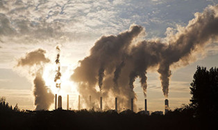
Apr 18, 2021Impact of emission from a coal-fired power plant on air quality
Coal combustion has been increasing rapidly in much of Asia, including in China and India (IPCC, 2013). Fine particulate matter (PM2.5: particles with an aerodynamic diameter of ≤2.5 μm) emitted/formed from coal combustion are key outdoor air pollutants of great environmental concern because they have serious adverse effects on public health (IARC, 2013).
-
Mar 30, 2021How can reduce the response of building structures to seismic excitations
Reinforced concrete (RC) is the most commonly used construction material used these days, primarily owning to its low cost, easy availability of materials, simpler execution without requirements of any special machineries or labour. Generally, the RC buildings are analyzed and designed such that, the moment resisting frame actions are developed in each member. The masonry infill wall are normally considered as non-structural elements used to create partitions or to protect the inside of the building and thus are ignored while analysis and design. However, under the action of lateral forces like the once due to earthquake and wind, these infill wall panel’s stiffness, strength and mass affect the behavior of RC frame building.Earthquakes are thus a severe structural hazard for structures designed for gravity loads as they may not sustain the horizontal shaking. Structures like buildings, elevated surface reservoir, bridges, towers, etc. may experience extreme vibrations during earthquake.
-
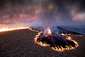
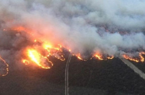
Mar 12, 2021How can reduce the risk of wildfires
Wildfires are a phenomenon that can alter ecosystems, damage property and infrastructure, and harm the wellbeing of at-risk populations. This trend in larger, more severe wildfires escalates the need for improved wildfire prevention planning by land managers. Improved planning requires fire risk mapping to identify the most at risk areas. Fire risk mapping has been an ongoing area of research for decades but no agreed upon method has yet been developed. Typically, fire risk mapping applies remote sensing and existing geographic data to acquire variables entered into a spatially explicit model to determine the hazard for specific areas and then evaluate the risk on the consequences of these hazards. This enables the land managers to address areas of high fire risk and reduce the current risk to better prepare for future fire events.
-
Mar 10, 2021How to predict forest fire: a new method may be useful
Definition of forest fire prediction: with investigation and determination of some natural and human factors, scientific technologies and methods are used to predict and predict the possibility of forest fire, potential fire behavior, the difficulty of controlling forest fire, and the loss caused by the forest fire.
-
Nov 20, 2020Notice on adjusting the frequency of publication
Dear authors:
Thanks to the efforts of editorial board members and editors, JGC has been supported and encouraged by more scholars. Thank you for your recognition and helpful suggestions. I would like to inform you that the publication frequency of JGC in 2021 has been changed to Semi-annual!
JGC editorial office
-
Aug 20, 2020Television and geography as big data: mapping a decade of television News
Geography is closely related to human life, and the application of geography technology can bring a new perspective for human to see the world.
-
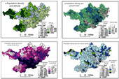
Jun 15, 2020To detect the influence of natural factors on the spatial distribution of regional population by geographic detectors
With the intensification of global climate change and resource and environmental problems, the relationship between people and geography has turned to re-examining the relationship between population, resources, environment and sustainable development. Based on spatial statistical analysis, facing new problems and new challenges, starting to learn from Quantitative research methods and techniques such as economics, behavioral science, systems science, and spatial information technology.